Posts

Showing posts from March, 2011

Geography Collective and Cultural Olympiad

Image
One of the things I'm proudest of in the last few years is my involvement with the Geography Collective , and our Mission:Explore books, iPhone app and other activities... We can now announce our latest project, thanks to the project leadership of Daniel Raven Ellison. We are very pleased to say that we will be delivering a major project for the Cultural Olympiad as part of the Discovering Places programme called  Discover Explore . Discovering Places is funded by a grant from Olympic Lottery Distributor (OLD) through the London Organising Committee of the London 2012 Olympic and Paralympic Games (LOCOG). It is delivered by The Heritage Alliance with the support of key partners.. one of which is us. We will be working closely with  The Workshop  to create something very beautiful and cool which will be launched this summer. “The project aims to inspire young people and their families to discover hidden, extraordinary and important historical sites and stories in cutting-e

Learning Score - get it while you can....

Image
John Davitt's genius lesson planning tool: LEARNING SCORE is now available for a limited time only as a FREE download with a lifetime license. I paid actual cash money for this about 6 months ago to use with teachers, so this is great news for those on limited budgets... To see how it might be used Doug Belshaw has made a video of him planning a history lesson .

Rory's Story Cubes

Image
During my lunch-time at the Education Show I took the opportunity to do a quick trip up and down the aisles to make sure that I saw as many of the stands as possible and have a chat to anyone who had a geographical connection, or who caught my eye. One stand I particularly wanted to see was the CREATIVITY HUB stand, where RORY's STORY CUBES were available. I have these cubes as an iPhone app and also as the infinitely preferable 'real thing', and have used them with many teachers over the last few years to explore the ideas of geography as "writing the earth". I have used my cubes with hundreds of teachers as a way of exploring creative writing, including my sessions at various conferences. By using a net for creating a cube such as the one below, taken from MATHS ISFUN  with thanks, you can also add your own cubes... Cut out the shapes and add your own words or instructions on the six sides relevant to the subject that you are using them for. If yo

Thinking about disasters...

Image
..is something that a lot of us have been doing for the last week... So have other colleagues...  Simon Jones has posted the results of his thinking on the presentation below, which he has shared on Slideshare. Some really interesting and challenging questions... Thinking about disasters View more presentations from Simon Jones There was also a response from the Guardian's DATA BLOG, which had a comparison between Japan and Haiti as part of its DECADE OF DISASTERS piece. There is also a useful NUCLEAR POWER feature which shows the number of power plants that may now have an uncertain future, and face far more stringent safety checks and procedures. Useful mapping in both of these features... Responses to the disaster have spread far and wide. Fears over the nuclear radiation that is likely to spread from the Fukushima plant caused salt to sell out in China. Thanks also to Fred Martin for sending through this intriguing link. This is all 6 major channels at

Subdivisions...

Image
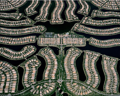
Got my ticket for the Rush 'Time Machine' tour in May at the Sheffield Arena: over 30 years of hard rocking and a full play through of 'Moving Pictures': it's going to be loud... One of my favourite Rush tracks is called 'Subdivisions'... There are plenty of amazing aerial images of the various Subdivisions of cities in the USA on Chris Gielen's TWISTED SIFTER blog. Here's one from Florida... And here, for your musical education (because this blog isn't just about geography you know...) are Rush performing the song live as part of the R30 tour... Lyrics by Neil Peart - plenty of geography here... Sprawling on the fringes of the city In geometric order An insulated border In between the bright lights And the far unlit unknown...

The Education Show

Image
The GA will have a stand at this year's  Education Show 2011 at the NEC. We will be in Hall 6&7 on Stand P30A - the subject association area (as at BETT) - the show starts later this week... Come along to pick up the latest catalogues, see some of our new publications, browse some GA resources and be told about the support for Primary and Secondary colleague that members can expect, as well as our CPD support and online networks. We would be interested to hear your views on the curriculum review, English Baccalaureate, and other challenges facing geography in schools, as well as the opportunities presented by these 'interesting times'. I will be setting up and manning the stand on the first day of the show: Thursday the 17th of March Alternatively, come with a USB drive and I'll let you have some free resources from my hard drive... I'll also be handing out various bits for those who get there early... My colleagues Nicola Donkin and Paul Baker wil

Another world-changing event...

Image
Just after 7am on Friday morning I pulled into a multi storey car park in central Coventry. I had set off rather earlier than I needed to ensure that I was on time for an NQT event that I was running, and as I checked my mail and Twitter feeds, news started to come in of an earthquake and tsunami... The rest of the day was spent running the conference, and by the time I got home at 7pm that night, there was a clear sense that this was going to be very bad news for Japan and the rest of the world... It became obvious that a lot of colleagues were hard at work over the weekend preparing a range of resources. My colleague Anne Greaves at the GA had produced a really useful page of materials at short notice on the Friday in my absence. Below is the text of the update that I will send to Anne for addition to the GA website tomorrow (Monday) but it is here for early access, and also for possible comment... This is a draft, and is my personal response to the events in Japan... Update

Great review for the new Mission Explore books...

From explorer Benedict Allen ... “This young explorers’ kit is endlessly adventurous – a journey in itself. An utter delight – full of surprises and things to make you look at the world afresh." The books will be published on the 1st of April

Wonders of the World

Image
I asked my Twitter followers to suggest/nominate a natural and a man-made "Wonder of the World" that (importantly) they had seen themselves... and to add the hashtag #nqtgeog11 Here are the results: Natural Wonders Colca Canyon, Peru Solheimajokull Glacier, Iceland Here's a picture of me on that very glacier in 2010: Jostedalsbreen, Norway Cheddar Gorge Tropical Rainforests Yosemite Valley The Cuillin Ridge, Skye Here's one of my images of a section of the said ridge: The Cenotes of the Chicxulub meteor impact in Mexico Cwm Idwal Landmannalaugar region of Iceland Valle de Mai, Praslin, Seychelles - home of the Coco de Mer Fingal's Cave Bryce Canyon, Utah The Alps Grand Canyon Man Made Wonders Guggenheim Museum, Bilbao Here are some pictures that I took when I visited.... Petra, Jordan (2 votes) Great Wall of China Serapeum, Temple of the Bulls near Cairo The CERN Large Hadron Collider Sydney Harbour Bridge (3 votes) The Londo

Urban News for a Sunday morning...

Image
There were 3 or 4 "urban-related" tweets in my overnight feed that I caught up with earlier 'today' while having my breakfast... Part of my daily routine now is to look at what has happened while I slept, and e-mail any interesting tweets to my e-mail account, so that I have a record of the links, and can follow them up when I have a moment... This weekend, there has been an urban theme to many of the updates. Several of them were from the excellent @urbanphoto_blog stream... You need to follow them if you don't already. One led me to the Twisted Sifter blog, from which I got this remarkable image , which apparently shows the suburbs of Mexico City marching into the distance, irrespective of topography. The images were from Pablo Lopez Luz I haven't explored the site further, but it seems to have a range of interesting images and other content. The second site, which was equally arresting is a description of the development of a new (or perhaps not

ESRI Mapping Tool

Image
A nice mapping tool produced by / for the ESRI Education community , which offers a range of base maps, and tools to draw on top of the base map to create a personal map. I liked the text tool, which allows labels to be placed by clicking on the map.  The finished map can then be saved or printed. Another option for map creation. Try it out